As a doctoral tandem project, Maik Blättermann and Anton Gass were researching the history of Late Bronze Age and Early Iron Age settlement and spatial utilization in the Zhetysu region of southeastern Kazakhstan, as well as the changes to the landscape and climate that took place in this period.
Research
Maik Blättermann: Geographie
Das Siebenstromland im Südosten Kasachstans ist reich an archäologischen Hinterlassenschaften der sakischen Kultur (800 Jh. bis 200 Jh. BC). Der geographische Part sollte klären, wie sich die Landschaft entwickelt hat und wie stark der Naturraum durch den Menschen verändert wurde.
Mit der Untersuchung des Landschaftshaushaltes wurde eine Differenzierung in Landschaftseinheiten mit ihren spezifischen Charakteristika (Hangneigung, Exposition) vorgenommen. Durch das Aufsuchen natürlicher Landschaftsarchive in ausdifferenzierten Landschaftseinheiten erfolgte eine Rekonstruktion der Paläoumwelt. Zur Chronologie der natürlichen Aufschlüsse waren absolute Datierungen ein wichtiger Bestandteil des Projektes. Nur dadurch waren Veränderungen im Landschaftshaushalt approximierbar.
Der Bezug im und zum Raum wird über ein Geographisches Informationssystem (GIS) hergestellt. Hier wurden archäologische und geographische Ergebnisse gebündelt. Dies half die weitere Fragestellung nach Zentralität der Landschaft für die sakische Kultur zu verstehen. Die Untersuchung wurde zusammen mit dem Archäologen A. Gass erarbeitet.
Die Dissertation wurde 2011 erfolgreich abgeschlossen und unter dem Titel “Spätholozene Landschaftsrekonstruktion im Siebenstromland (Kasachstan). Ein geoarchäologischer Forschungsbeitrag” veröffentlicht.
Anton Gass: Archaeology
 with procession way (Ø=252m) | © Anton Gass")
Fig. 1: Royal kurgan of Asy Saga (K1, h=21m, Ø=149m) with procession way (Ø=252m) | © Anton Gass
Study site of our geoarchaeological investigation was located at the “Zhetisu”, south-east Kazakhstan, which is characterized by grave monuments. These kurgans are remains of the “Sakes” culture, which inhabited the area in the early Iron Age (1st mill. BC). “Sakes” people are described as mounted warrior nomads and are a part of Scythian culture group in eastern Eurasian steppe belt. Certainly, grave monuments have been mapped insufficient. In northern Ili-Valley the kurgan of Besshatyr or royal kurgans of Issyk have been investigated and published, but with inadequate modern standards. Archaeological monuments in the mountain valleys were mapped and their topographical location analyzed. There geomorphological location and spatial distribution in Land of Seven Rivers were investigated (Fig. 1).
Objectives and Results
Because of the fact, that Zhetisu provides a different account as the other parts of the steppe during the period of ´Warrior nomadism´, it gave the unique opportunity to study on the one hand the development of the social stratification and on the other hand the development of landscape use.
The aim of this project was to answer questions about how “Sakes” inhabited the land and were they agropastoralists beside their nomadic live. Further, if one could detect any evidence for an increase of morphodynamic activity beside their nomadic live. On the basis of aerial photographs, satellite images and topographical maps the development of the economy (animal husbandry and agriculture, both existing together in the region) and of the social system (on the basis of the studied and mapped burial grounds) can be traced and understood. The analysis of images and maps was combined with a detailed survey during the visible monuments. It was recorded and mapped (with GPS) to provide an image of the cultural and sedentary development of the Bronze and Early Iron Age.
We also have to consider a profound change that has been established in all regions of the Eurasian steppe belt. At the moment that mounted warrior cultures develop, not only economic but also social systems changed, which can be seen in the monumental burials with sumptuous inventories. The continuously growing mobility of pastoral nomadic societies since the late Bronze Age, led to a new understanding of space and the opening and use of new spaces.
These processes could be visualized through geoarchaeological analyses, especially through the analyses of the kurgan burial grounds of “Saka-groups” and of the build-up of large burial grounds, which can be seen as the central burial grounds for their respective regions.
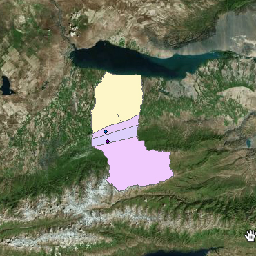
Centrality
Constantly growing of mounted nomads of “Sakes” people in late Bronze Age, a new approach of landscape use and enhancement in spatial environment has been established. Especially trough investigation in spatial distribution of kurgan-fields and their inner structure research gives evidence for centrality of necropolis of this region (Fig. 2).
 | © Anton Gass")
Fig. 2: Overview of geoarchaeological research at Zhetisu, south-eastern Kazakhstan (archaeological results) | © Anton Gass
Adjustment of kurgans and special outer circle form is parallel through kurgan fields of the North Pontic Region. Antique authors like Herodotus described, that kurgans alike Scythian sacrifices (Herodotus, The Histories. Book 4, Melpomene, 62). Further he mentioned that places of elite necropolis from “Scythian/Sakes” time are a conceptional place, which plays a primaries role (Herodotus, The Histories. Book 4, Melpomene, 71 & 127). In such a way analyzed necropolis aren´t only burial places, but also sacred places for central identification of “Sakes”.
This dissertation was successfully completed in 2012. An excerpt of the dissertation is publicated in: Anton Gass, “Das Land der sieben Flüsse im 2. bis 1. Jahrtausend v. Chr”, in: Volume 3 (2014), eTopoi. Journal for Ancient Studies, 3 (2014)
Related Links
 Research results of this project are presented in layer-based spatial maps created with the Topoi WebGIS application. The application complies with OGC specifications. Selected layers can be downloaded in different shapes. Learn more